 4.
Darrington
4.
Darrington
Updated August 2014
This section used to have a lot more going for it, but in February 2012, Snohomish County's Community Transit enacted substantial cuts to bus service throughout their system. Hardest hit, as is often the case, were outlying and rural routes, including the one route extending to Darrington. It was cut from eight runs a day to only two, with no weekend service at all.
Sadly, the first run leaves its starting point in Arlington just a bit too early for you to have reached it if you were beginning in Seattle (if you had started out in Everett, you could still reach the early bus--see CT for schedule info). So the only other bus gets you to Darrington at 6:00 in the evening, much too late to do anything--even at the height of summer--other than to walk 3 miles south from town to reach the Clear Creek Campground.
(The only reasons this Chapter is still here is that 1) I hope the transit cutbacks are only temporary; and 2) I didn't want to have to renumber the whole Backpacking by Bus site.)
Darrington used to be the closest town to the famed Kennedy Hot Spring, but alas, it's gone. Simply gone. Don't get your hopes up. It's gone. In late October '03 a large weather system blew into western Washington, dumping a record five inches of rain on Seattle in twenty-four hours. It filled the rain gauge in Darrington to ten inches in the same span. An estimated foot of rain walloped the west side of Glacier Peak, causing a huge debris slide to come crashing down White Chuck Creek, burying the two-acre site of the hot spring with ten to fifteen feet of silt, boulders, and downed trees. It buried the spring itself, and tore out the bridge across the White Chuck at the spring, as well as the nearby bridge across Kennedy Creek. The event caused several sections of the five-mile trail leading to the site to slump or slide into the White Chuck; several sections of the eleven-mile White Chuck River Road met a like fate.
In October 2011, the White Chuck River Road was reopened to about 5.5 miles, to just past Straight Creek Road #27. The former White Chuck Road beyond that point has been decommissioned: there are no plans to rebuild it. So, although you cannot use the reopened road to reach anywhere near the site formerly known as Kennedy Hot Spring, the reconnection with the Straight Creek Road will open up some (admittedly, very long) options into the Glacier Peak Wilderness.
One would be a pair of lakes, Crystal and Meadow, though the lakes themselves seem hardly worth all the walking. The other option would be to use Darrington as an out-route for trips originating either at Holden Village above Lake Chelan, or at Stevens Pass, curling around the north side of Glacier Peak along the Pacific Crest Trail. These would be major, late-season journeys of 60-plus miles, but take a look at a map: Darrington would be an obvious exit point (or entrance point, for that matter).
Trail Options: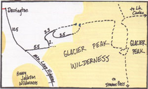 A
- Crystal Lake / Meadow Lake
A
- Crystal Lake / Meadow Lake
bus stop to trailhead: 20 miles, or 23.5 miles
trailhead to Crystal: 3.3 miles
trailhead to Meadow: 2.7 miles
Walking twenty-plus miles for a five or six mile hike is kinda' silly. I would probably only do this hike as part of a much larger trip, to continue along the ridge east of Meadow Lake, eventually going off-trail to reach the PCT, and heading east toward Lake Chelan, or south to Stevens Pass. Or the reverse.
But here are the initial directions: Head south from Darrington along the Mountain Loop Highway for 10.5 miles, turning east onto the White Chuck River Road. Proceed 5.5 miles, then turn north onto F.S. Road #27 (Straight Creek Road). About two miles further on, you'll have two options: follow Trail 638 for 3.3 miles to Crystal Lake, or follow Road 2710 another 3.5 miles to Trail 657, taking you to Meadow Lake.
For a third option (there's always a third option), the two lakes are only about half a mile apart, and the saddle between them looks entirely doable (I'd be quite surprised if there wasn't some sort of fisherman's trail already there).
Concerning the option of reaching the Pacific Crest Trail: Take a good look on a topo map at the ridge to the east of the lakes--it eventually reaches Fire Creek Pass at the northwest corner of Glacier Peak. It all depends on your off-trail confidence. You could stay on-trail and go all the way south to the Kennedy-White Chuck area, but, remember, those two bridges, as of this writing, have not yet been replaced. And those two creeks, even in late summer, are the kind of creeks that can easily drown you.
BUS STUFF:
Seattle to Darrington (Mon thru Fri only)
| Bus | Leaves | Time | Arrives | Time |
| Sound Transit 512 | lvs. 4th &Pike Seattle |
2:24 PM | arr. Lynnwood Transit Center |
2:52 PM |
| Community Transit (CT) 201 | lvs. Lynnwood TC Bay B4 |
3:22 | arr. Smokey Pt. Transit Center |
4:40PM |
| Community Transit (CT) 230 | lvs. Smokey Pt. Tr. Ctr. |
4:54 PM | arr. Darrington | 6:03 PM |
Darrington to Seattle (Monday through Friday only) - early run
| Bus | Leaves | Time | Arrives | Time |
| CT 230 | Darrington | 7:33 AM | arr. Smokey Pt. | 8:40AM |
| CT 201 | lvs. Smokey Pt. |
8:49AM | arr, Everett Station | 9:29AM |
| Sound Transit 512 | Everett Station | 9:30AM | arr. Seattle | 10:30AM |
Darrington to Seattle (Monday through Friday) - late run
| Bus | Leaves | Time | Arrives | Time |
| CT 230 | Darrington | 7:00 PM | arr. Smokey Pt. | 8:07PM |
| CT 202 | Smokey Point | 8:24PM | Everett Station | 9:05 PM |
| Sound Transit 512 | Everett Station | 9:30 PM | Seattle | 10:22 PM |
Fares:
| Sound Transit | $3.50 |
| Community Transit | $1.75 (transfers no longer issued unless using Orca Card) |